The interaction of subglacial volcanoes and their overlying ice cover is characterised by large-scale floods, jökulhlaups, carrying sediment, fresh volcanogenic material and ice. Iceland’s stratovolcanoes, Öræfajökull, Eyjafjallajökull and Snæfellsjökull erupt less frequently than Hekla, Katla and Grímsvötn and thus dwell less on public consciousness as significantly hazardous neighbours. They however pose no less important hazards because when they do erupt these high, cone-shaped ‘quiet’ volcanoes produce dramatic jökulhlaups along short, steep paths towards nearby communities. Since all these volcanoes are close to the coast, jökulhlaups flowing into the sea can trigger tsunamis.
Öræfajökull (highest peak 2119 m, 13 peaks higher than 1500 m) is a steep, ice-covered cone which has erupted twice since Iceland was settled producing devastatingly catastrophic floods which killed both people and animals, destroyed farming land and resulted in abandonment or destruction of farm sites. The eruption in 1362 was exceptionally large, perhaps the third largest Icelandic eruption in the Holocene. The Eyjafjallajökull central volcano (1666 m high) is only known to have erupted twice for certain in the Holocene. In 1821-3, the only well documented historical event, the eruption sent a flood north from the ice-filled crater.
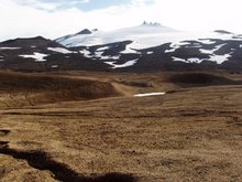
Snæfellsjökull, like Öræfajökull and Eyjafjallajökull, is a high ice-capped cone (1446 m) rising up from sea level with a 200 m deep summit crater completely infilled with ice. Three eruptions are known of in the Holocene, the most recent around 1750 radiocarbon years ago produced lava and tephra-fall. Snæfellsjökull is the central focus of a national park, a popular tourist location within sight of Reykjavík. Should a flood occur here in the future, the communities and tourist centres throughout the national park, several farms, airfields, the main road and bridges may all be within the most hazardous regions.