Holocene Jökulhlaups from Snæfellsjökull, west Iceland

Background

The interaction of subglacial volcanoes and their overlying ice cover is characterised by large-scale floods, jökulhlaups, carrying sediment, fresh volcanogenic material and ice. Iceland’s stratovolcanoes, Öræfajökull, Eyjafjallajökull and Snæfellsjökull erupt less frequently than Hekla, Katla and Grímsvötn and thus dwell less on public consciousness as significantly hazardous neighbours. They however pose no less important hazards because when they do erupt these high, cone-shaped ‘quiet’ volcanoes produce dramatic jökulhlaups along short, steep paths towards nearby communities. Since all these volcanoes are close to the coast, jökulhlaups flowing into the sea can trigger tsunamis.

Öræfajökull (highest peak 2119 m, 13 peaks higher than 1500 m) is a steep, ice-covered cone which has erupted twice since Iceland was settled producing devastatingly catastrophic floods which killed both people and animals, destroyed farming land and resulted in abandonment or destruction of farm sites. The eruption in 1362 was exceptionally large, perhaps the third largest Icelandic eruption in the Holocene. The Eyjafjallajökull central volcano (1666 m high) is only known to have erupted twice for certain in the Holocene. In 1821-3, the only well documented historical event, the eruption sent a flood north from the ice-filled crater.

Snæfellsjökull, like Öræfajökull and Eyjafjallajökull, is a high ice-capped cone (1446 m) rising up from sea level with a 200 m deep summit crater completely infilled with ice. Three eruptions are known of in the Holocene, the most recent around 1750 radiocarbon years ago produced lava and tephra-fall. Snæfellsjökull is the central focus of a national park, a popular tourist location within sight of Reykjavík. Should a flood occur here in the future, the communities and tourist centres throughout the national park, several farms, airfields, the main road and bridges may all be within the most hazardous regions.

Aims and objectives

The aim of this research is to reconstruct past flood/flow events in Iceland in order to assess and manage future hazards. Specifically this research will investigate the timing, nature and intensity of flood/flow events from Snæfellsjökull in west Iceland.

Research objectives:

  • Determine if Snæfellsjökull has been subject to volcanic flood activity or rain-triggered lahars during the Holocene.
  • If so, map and produce a chronology of these events.
  • Produce a hazard map of zones of inundation and risk.
  • Produce a tephrochronological framework in which to place this environmental record.

Methodology

To answer these questions this project will rely on a well developed methodology based on the use of geomorphological, sedimentological and chronological techniques to provide a palaeoenvironmental reconstruction. Key elements of this are the production of 1:10,000 scale geomorphological maps from aerial photographs and ground survey, description and grain-size analysis of likely flood deposits and dating using a framework of volcanic ‘ash’ layers (tephra) in the regions (e.g. Jóhannesson 1981). Electron microprobe analysis of key tephras and the matrices of flood deposits will be carried out at the University of Edinburgh Tephrochronology Unit.

Preliminary results and interpretation

Extensive deposits of rounded pumice clasts found in channels and along the margins of channels (over-bank deposits) to the west and south of the volcano, originating at glacier margins to the north-west, west and east. In some cases geomorphological evidence such as cataracts and boulder deposits point to unusually large flows over post-glacial lava surfaces.

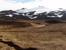
Particularly thick (more than 5 metres high) deposits are found close to the ice margins, and overlying glacial ice-marginal landforms to the north and east of the volcano. It is as yet unclear if these are primary airfall deposits or flood deposits.

Geomorphological mapping, preliminary sedimentary investigations carried out since the summer of 2005 and points noted by Jóhannesson and others (2001) during tephrochronological studies indicate that there have in the past been at least three main flood routes associated with eruptions. Pumice left by tephra fall and jökulhlaup deposition during the last eruption is found in very thick deposits close to the northern and eastern contemporary glacial limits. As well as eruption-related jökulhlaups the presence of these thick, light-weight, unconsolidated deposits could have resulted in an extended period of rain-triggered reworking of material in lahars and damming of drainage routes by accumulations of erupted and flood-deposited material.

Jóhannesson, H., Flores, R. M. and Jónsson, J. 1981. A short account of the Holocene tephrochronology of the Snæfellsjökull central volcano, Western Iceland. Jökull, 31, 23-30.

Related presentations

Information here on preliminary results of this project has been presented at the International Glaciological Society international symposium on earth and planetary ice-volcano interactions in Reykjavík in June 2006 and the abstract for this talk is published in:

K.T.Smith (2006) ´Jökulhlaups from Snæfellsjökull, west Iceland´ IGS International Symposium on Earth and Planetary Ice-Volcano Interactions, Reykjavík, Iceland. 19th - 23rd June 2006, Abstract volume, Abstract no: 45A049.